King Alfreds Tower 18th Century Commemoration of the seven year French War
Link Location Gps ← Find Best directions
Gps Coordinates / 51.1150017,-2.3641667
King Alfreds Tower England VR 360 Tourism
Kingsettle Hill, South Brewham, Bruton BA10 0LB England
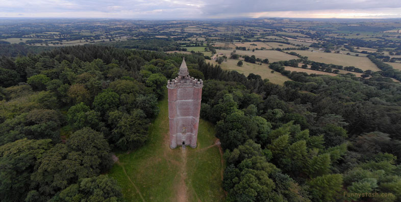
Henry Hoare II planned the tower in the 1760s to commemorate the end of the Seven Years War against France and the accession of King George III near the location of Egbert's Stone, where it is believed that Alfred the Great, King of Wessex, rallied the Anglo-Saxons in 878 before the Battle of Edington. The tower was damaged by a plane in 1944 and restored in the 1980s.
Gps Coordinates / 51.1152463,-2.3650757
The 49-metre-high (161 ft) triangular tower has a hollow centre and is climbed by means of a spiral staircase in one of the corner projections. It includes a statue of King Alfred and dedication inscription.
Gps Coordinates / 51.1149428,-2.3651028
King Alfred's Tower is a folly in Somerset, England, on the edge of the border with Wiltshire, on the Stourhead estate. The tower stands on Kingsettle Hill and belongs to the National Trust. It is designated as a grade I listed building.
Link Location Gps / Gps Link -2.3651699 / Gps Link -2.3648802 / Gps Link -2.3652262
Gps Coordinates / 51.1149291,-2.3651699 / 51.1149592,-2.3648802 / 51.1148022,-2.3652262
In 1765 Henry Flitcroft, a Palladian architect, designed the tower. Building began in 1769 or early 1770, and was completed in 1772 at an estimated cost between £5,000 and £6,000. There may have been some delay due to difficulty in obtaining the bricks. In addition to the commemorative function, the tower was also intended to serve as an eye-catching focus for those touring the parkland of the Stourhead Estate.
Link Location Gps / Gps Link -2.3651344 / Gps Link -2.3644447 / Gps Link -2.3650016
Gps Coordinates / 51.1147483,-2.3651344 / 51.1149685,-2.3644447 / 51.1148135,-2.3650016
In April 1770, when the tower was just 4.7 metres (15 ft) high, Hoare is quoted as saying: "I hope it will be finished in as happy Times to this Isle as Alfred finished his Life of Glory in then I shall depart in peace."
Link Location Gps / Gps Link -2.365011 / Gps Link -2.3649248 / Gps Link -2.3649614
Gps Coordinates / 51.1148563,-2.365011 / 51.114838,-2.3649248 / 51.114786,-2.3649614
The tower was damaged in 1944 when an aeroplane, a Noorduyn Norseman ironically, crashed into it, resulting in the death of the five aircrew and damage to the highest 10 metres (33 ft). It was designated as a Grade I listed building in 1961. The tower was restored in 1986, which included the use of a Wessex helicopter to lower a 300-kilogram (47 st) stone onto the top. The statue of King Alfred was also restored at this time, including the replacement of his missing right forearm.


