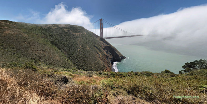
Golden Gate Bridge described in Frommer's travel guide as "possibly the most beautiful, certainly the most photographed, bridge in the world."
Link Location Gps ← Find Best directions
Gps Coordinates / 37.8279753,-122.4858399
Golden Gate Bridge VR San Francisco USA
Golden Gate Bridge, San Francisco, CA, United States
The Golden Gate Bridge is a suspension bridge spanning the Golden Gate, the one-mile-wide (1.6 km) strait connecting San Francisco Bay and the Pacific Ocean.
More than 1,500 deaths from 1937 opening until 2017 prevention methods were installed
Link Location Gps -122.4858702
Gps Coordinates / 37.8275818,-122.4858702
The bridge was closed because of weather conditions only three times during 20th Century. On December 1, 1951, because of gusts of 69 mph. On December 23, 1982, because of winds of 70 mph (113 km/h) and on December 3, 1983, because of wind gusts of 75 mph
The structure links the U.S. city of San Francisco, California
Link Location Gps / Gps Link -122.4860786 / Gps Link -122.4860005 / Gps Link -122.4860306
Gps Coordinates / 37.8288642,-122.4860786 / 37.8285366,-122.4860005 / 37.8282509,-122.4860306
After years of debate and an estimated more than 1,500 deaths, suicide barriers, consisting of a stainless steel net extending 20 feet from the bridge and supported by structural steel 20 feet under the walkway, began to be installed in April 2017.
It was initially designed by engineer Joseph Strauss in 1917
Link Location Gps / Gps Link -122.4860942 / Gps Link -122.4861946 / Gps Link -122.4860117
Gps Coordinates / 37.8282763,-122.4860942 / 37.828319,-122.4861946 / 37.827625,-122.4860117
Strauss wrote a poem that is now on the Golden Gate Bridge entitled "The Mighty Task is Done."
The bridge was named for the Golden Gate strait, the channel that it spans.
Link Location Gps / Gps Link -122.4810866 / Gps Link -122.4811558 / Gps Link -122.4811066
Gps Coordinates / 37.8272892,-122.4810866 / 37.8273552,-122.4811558 / 37.8273165,-122.4811066
The northern tip of the San Francisco Peninsula, to Marin County, carrying both U.S. Route 101 and California State Route 1 across the strait.
Its main span is 4,200 feet (1,280 m) and total height is 746 feet (227 m)
Link Location Gps / Gps Link -122.4776527 / Gps Link -122.479187 / Gps Link -122.4792404
Gps Coordinates / 37.8265341,-122.4776527 / 37.8259506,-122.479187 / 37.8257294,-122.4792404
It also carries pedestrian and bicycle traffic, and is designated as part of U.S. Bicycle Route 95.
The bridge-opening celebration in 1937 began on May 27 and lasted for one week
Link Location Gps / Gps Link -122.4800273 / Gps Link -122.4773093 / Gps Link -122.4780218 / Gps Link -122.4783943
Gps Coordinates / 37.8215548,-122.4800273 / 37.8106919,-122.4773093 / 37.8082113,-122.4780218 / 37.8077671,-122.4783943
Being declared one of the Wonders of the Modern World by the American Society of Civil Engineers, the bridge is one of the most internationally recognized symbols of San Francisco and California.
At the time of its opening in 1937, it was both the longest and the tallest suspension bridge in the world, titles it held until 1964 and 1998 respectively.
The day before vehicle traffic was allowed, 200,000 people crossed either on foot or on roller skates
Link Location Gps -122.4858577
Gps Coordinates / 37.828925,-122.4858577
An official song, "There's a Silver Moon on the Golden Gate," was chosen to commemorate the event.
The next day, President Franklin D. Roosevelt pushed a button in Washington, D.C. signaling the official start of vehicle traffic over the Bridge at noon.


