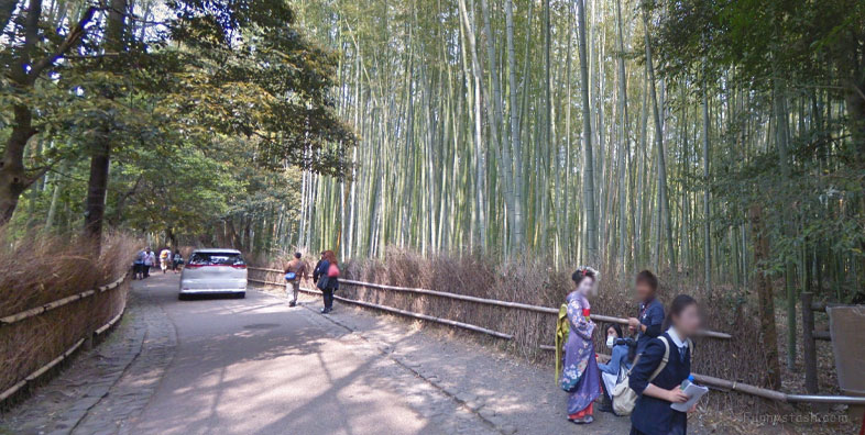
Natural wild forest of bamboo in Arashiyama Kyoto Japan
Link Location Gps ← Find Best directions
Gps Coordinates / 35.0176246,135.6740929
Bamboo Forest Arashiyama Japan Vr Gps 360 Tourism
Japan, 〒616-8375 Kyoto, Ukyo Ward, Sagatenryuji Tateishicho, 1
The forest consists mostly of Moso Bamboo (Phyllostachys edulis) and consists of several pathways for tourists and visitors. The Ministry of the Environment considers it a part of the soundscape of Japan.
Rickshaw rides from the young Japanese men and go through the bamboo forest path and around Arashiyama
Gps Coordinates / 35.0175907,135.6744795
The Sagano Bamboo Forest is situated northwest of Kyoto in Japan near the Tenryū-ji Temple. It covers an area of 16 square kilometers, in the temperate regions of the world.
Link Location Gps / Gps Link 35.016542 / Gps Link 35.0164999 / Gps Link 35.0174115
Gps Coordinates / 35.016542,135.6703077 / 35.0164999,135.6703379 / 35.0174115,135.6703205
The region experiences unpredictable weather with a rather cool climate and bright sunlight. In this region the summers are short, hot, and mostly cloudy.
Link Location Gps / Gps Link 35.0173416 / Gps Link 35.017069 / Gps Link 35.0168117
Gps Coordinates / 35.0173416,135.670263 / 35.017069,135.6718982 / 35.0168117,135.6713214
The winters are very cold, windy, and partly cloudy. It is also wet year-round.
Link Location Gps / Gps Link 35.0173053 / Gps Link 35.0173327 / Gps Link 35.0173731
Gps Coordinates / 35.0173053,135.6748746 / 35.0173327,135.674959 / 35.0173731,135.6751808
Over the course of the year, the temperature typically ranges from 32°F to 89°F. The Summers last for approximately 2 months, from June 23 to September 17, with an average daily high temperature above 80°F.
Many people come here to enjoy an authentic Japanese rickshaw tour
Link Location Gps / Gps Link 35.0174103 / Gps Link 35.0174546 / Gps Link 35.0175205
Gps Coordinates / 35.0174103,135.6754876 / 35.0174546,135.6758892 / 35.0175205,135.6761339
The winters last for approximately 3 months, from December 3 to March 18, with an average daily high temperature below 53°F.
Link Location Gps / Gps Link 35.0184839 / Gps Link 35.0186432 / Gps Link 35.0191051
Gps Coordinates / 35.0184839,135.6740856 / 35.0186432,135.6744544 / 35.0191051,135.6744874
Arashiyama (嵐山, Storm Mountain) is a district on the western outskirts of Kyoto, Japan. It also refers to the mountain across the Ōi River, which forms a backdrop to the district. Arashiyama is a nationally designated Historic Site and Place of Scenic Beauty. Notable for its views of cherry blossoms and autumn colors on the slopes of Arashiyama.
Link Location Gps / Gps Link 35.0187942 / Gps Link 35.0189802 / Gps Link 35.0166639
Gps Coordinates / 35.0187942,135.67447 / 35.0189802,135.6741595 / 35.0166639,135.6707633
The Japanese have a long history with bamboo, in myths and legends, metaphorically linking a man's strength with this plant. Many festivals also include the use of bamboo in various forms.
Link Location Gps / Gps Link 35.0167445 / Gps Link 35.0167621
Gps Coordinates / 35.0167445,135.67102 / 35.0167621,135.671143
You can rent a bike or stroll the path to enjoy the beautiful sight of sunlight shining through the bamboo grove, casting soft shadows on the path. Especially when the wind blows through, you can see moving images exuding a tranquil feel. That is the true charm of these forests of the east.
Gps Coordinates / 35.0166276,135.6707561
You can access it directly from the main street of Arashiyama, a little to the north of the entrance to Tenryu-ji Temple, but it’s best paired with a visit to that temple (exit the north gate, take a left and you’ll be in the grove in no time).
Gps Coordinates / 35.0167922,135.6712352
There’s just one main path through the grove, which leads slowly uphill. Once you get to the top of the hill, the entrance to the sublime Okochi-Sanso Villa is right in front of you (go in, you won’t regret it).


